Eagle Owl – South Africa’s own UAV
Fixed-wing drone manufacturer and supplier Aerial Monitoring Solutions (AMS) started production of the Eagle Owl back in 2016 and has seen the biggest demand for its UAV drones in Africa, mainly for mining surveying and security.
There is a wide selection of drones available on the marketplace, with only one commercial drone manufactured in South Africa for civilian use.
With agents in sub-Sahara, West and East Africa, AMS has achieved success with its multi-purpose, robust all-weather drone, perfectly suited to developing countries, with simple, easy-to-replace basic technology.
Design
Designed in a modular manner, the payload compartment, wings and fuselage can be repaired or replaced individually within a short time frame once an AMS agent is in place and there is no damage to electronics. The design also allows for customisation, which allows various equipment to be placed on board for different requirements such as surveying a mine, night time when flying cameras of varying ability can be used, At night, the drone might be needed for doing security patrols, in which case a payload with a thermal camera is used.
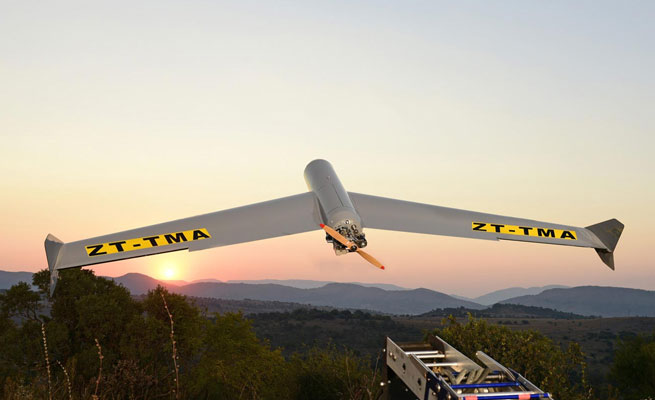
The Eagle Owl drone weighs nearly 13.5 kg, owing to its fibreglass and carbon-fibre components, and the engine of each drone is petrol-powered. The drones can fly for nearly four to five hours, depending on the weather.
“The drone uses a rail launching system. The 4-m-long rail uses bungee cords to ensure a perfect take-off. The whole system takes about ten minutes to set up and can easily be transported on the back of a truck,” says said Adam Rosman, founder and managing director of Aerial Monitoring Solutions, adding that the rail has a safety pin to ensure that the drone does not launch before the operator decides to launch it.
Ideal for DDD conditions
According to Rosman, a major benefit of UAVs is they are well suited for use in dangerous, dull and dirty (DDD) conditions and can be used for surveillance and search and rescue work far more cost effectively than helicopters or fixed wing aircraft where pilots can find themselves in dangerous situations.
The drone is capable of both a belly landing and a parachute landing, and is equipped with a Global Positioning System (GPS) and black box in case it is blown off course, or an accident occurs. It is also equipped with a full autopilot system, and operators can simply plug GPS coordinates into the system and launch. The drone can be sent to fly a predetermined route, with the pilot overseeing the operation, Rosman points out.
The aircraft has an operational radius of 10km but this can be extended up to 100km with live data and high definition (HD) video being streamed in real-time. It can be flown manually or pre-programmed to fly on auto-pilot and its flight path is charted and controlled on a ground controlled base station.
High restrictions
The Eagle Owl can fly to a height of 19 000 feet but is restricted by SA Civil Aviation Authority (SACAA) regulations to fly no higher than 400 feet. It cruises at 100km/h with a top speed of 120km/h.
“SA is a world leader in the implementation of rules permitting UAVs to fly beyond the visual line of sight of the operator, which allows for legal long-distance flights by these unmanned aircraft,” says Rosman. “These new regulations have opened the way for SA to become one of the world’s largest commercial operators of UAVs.”
Anti-poaching
Aerial Monitoring Solutions says its drones can be used by anti-poaching initiatives; to monitor cattle theft; to help farmers with game and cattle counting; for wildlife research and monitoring; and to monitoring breaches in farm and property fences. Rosman and some of his team have hands-on experience in the anti-poaching field, having been involved with Ezemvelo KZN Wildlife, the provincial conservation agency which oversees fauna and flora protection in KwaZulu-Natal.
Drones can also be used for monitoring borders, power lines, railway lines and other infrastructure that might be susceptible to vandalism and cable theft; for inspecting roads and bridges; and for photography and fire monitoring. Search and rescue missions in out-of-reach and dangerous locations; disaster relief efforts; transporting medicines to rural areas; terrain mapping and 3D mapping; parcel drops; and crowd control can all be done with drones.


